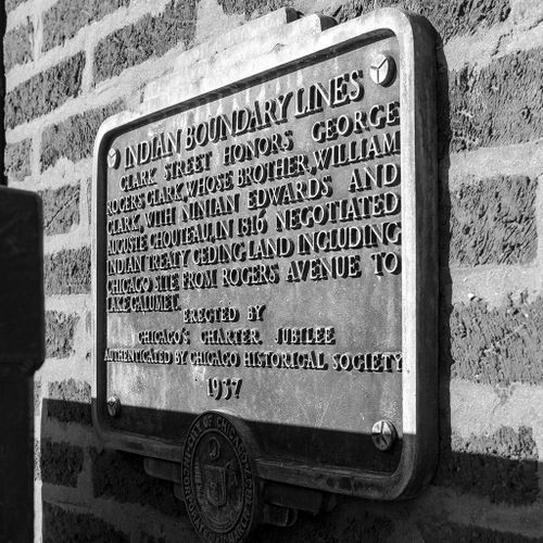
Indian Boundary Lines Plaque
Title
Indian Boundary Lines Plaque
Date
1937
Artist
Vernacular
Location
Rogers Avenue and Clark Street
Context
The city installed a lighting box directly in front of the marker, making it difficult to spot. Inscribed: "Indian Boundary Lines - Clark Street honors George Rogers Clark, whose brother William Clark, with Ninian Edwards and Auguste Chouteau, in 1816 negotiated Indian treaty ceding land including Chicago site from Rogers Avenue to Lake Calumet. - Erected by Chicago's Charter Jubilee - Authenticated by Chicago Historical Society - 1937." According to the website, EarlyChicago.com, "The plaque commemorates the successful efforts of Gov. Ninian Edwards and others to negotiate with local Indian tribes, at the 1816 Treaty of St. Louis, the acquisition by the United States of a tract of land, 20 by 70 miles, that extended from Lake Michigan to the Illinois River near Ottawa and included Chicago, the portage, and the area for which construction of a canal between the Great Lakes and the Mississippi River system was contemplated. Rogers Avenue now forms part of the northern boundary of this tract; Indian Boundary Road southwest of Plainfield also follows this northern line."